Riverside Park History

People look north to the Riverside Church, 1940
People in the Park at around 113th Street, looking north to Riverside Church – 1940
Living Land Acknowledgement

Riverside Park History

Riverside Park is located on unceded Lenni-Lenape land – Lenapehoking — which covers parts of today’s New Jersey, Pennsylvania, and New York.

As supporters of a public green space in New York City, we recognize the devastating history of colonization on the land here, and the ongoing impact colonialism has on Native communities, their homelands, local ecologies, and the planet at large. In order to deliver truly holistic care to Riverside Park, we must move from an understanding of this land’s history – and look to Lenape-led efforts to inform and shape our land stewardship model.

We encourage you to learn more about – and from – the native residents of this region. Lenapecenter.com is a place to start here in the City, as well as The Land We’re On: Living Lenapehoking from the New York Public Library.

We also recommend looking into the teachings of Robin Wall Kimmerer, and reading her book, Braiding Sweetgrass: Indigenous Wisdom, Scientific Knowledge and the Teachings of Plants.


Before the topography of the island was altered, the rugged western shoreline of the island of Manahatta was home to cliffs, mature woodlands, sandy beaches, and streams that made their way down to the river, known to the Lenape as Muhheakunnuk, The River that Runs Both Ways.

Starting in the early seventeenth century, European colonizers began to populate the island, engaging in trade with the Lenape and creating farms and country estates on the then-rural landscape. The Lenape population declined drastically in this period due to a combination of disease, starvation, and forced displacement by the settlers.

In the eighteenth century, the river, which became known as the Hudson River, evolved into a commercial and transportation artery to Albany and other cities and towns to the north, resulting in the beginnings of the industrialization of the West Side waterfront at the beginning of the nineteenth century.

The construction of the Hudson River Railroad, later the New York Central Railroad, in 1846, would add another layer of industry to the mix.

Two people walk on a path in the early 20th Century
Two people walk on a path in the early 20th Century.

The 191 acres of land which form the original area of Riverside Park (from 72nd to 125th Streets) were undeveloped prior to the Hudson River Railroad, built in 1846 to connect New York City to Albany. The first proposal to convert the riverside precipice into a park was contained in a pamphlet written by William R. Martin, a parks commissioner, in 1865. Riverside Park was acquired and designed in several stages. In 1866, a bill introduced into the Legislature by commissioner Andrew Green was approved, and the first segment of park was acquired through condemnation in 1872. Landscape architect Frederick Law Olmsted prepared the conceptual plan for the new park and road, Riverside Drive. Subsequently, a series of designers set out to devise the new landscape, incorporating Olmsted’s idea of a park with a tree-lined drive curving around the valleys and rock outcroppings and overlooking the river. From 1875 to 1910, architects and horticulturalists such as Calvert Vaux and Samuel Parsons laid out the stretch of park between 72nd and 125th Streets according to the English gardening ideal, creating the appearance that the Park was an extension of the Hudson River Valley.

Construction taking place to cover the railroad tracks in 1937
Railroad tracks were covered and the expansion of Riverside Park was to be built on top of them – 1937

With the beginning of the City Beautiful Movement in the early twentieth century, the landscape evolved. The Park began to serve as a repository for monuments and sculptures, and its border was extended north to 155th Street. F. Stuart Williamson designed the extension with its decorative viaduct, castle-like retaining walls and grand entry ensembles. In 1937, during Robert Moses’ administration, the Park underwent another growth phase, with the addition of 132 acres of land along the entire expanse of the Park. In planning the new area, landscape architect Gilmore D. Clarke and architect Clinton Loyd focused on creating recreational spaces. This is also when the Henry Hudson Parkway (extending from 72nd Street north to the Bronx-Westchester county boundary ) was constructed under Robert Moses’ direction. The highway cuts through Riverside Park, effectively slicing it into several sections.

After more than a half century of development, a park combining nineteenth and twentieth century landscape design concepts was created. Its unique beauty was formally recognized in 1980, when the section from 72nd to 125th Street was designated a scenic landmark by the New York City Landmarks.

People gather at annual Little Red Lighthouse Festival
The Conservancy partners with the Historic House Trust to host a free annual Little Red Lighthouse Festival for the public

Today, Riverside Park Conservancy also cares for a stretch of Fort Washington Park – from 155th to 181st Streets – along the shoreline. Fort Washington Park was acquired by the city in 1894, and was also designed by Frederick Law Olmstead. In the early 1900s, more areas were acquired as part of the Park, which consists of 160 acres and connects to Fort Tryon Park to the north. Upon construction of the Fort Washington Bridge, Port Authority acquired jurisdiction of part of the Park. The famous Little Red Lighthouse at 181st Street, installed in 1927, was almost removed in the 1940s when it became obsolete after the construction of the George Washington Bridge. Community organizing – led by local children – successfully advocated for the Lighthouse to stay. It is a cherished New York City Landmark and is on the National Register of Historic Places, and is the site of the Conservancy’s Summer on the Hudson annual Little Red Lighthouse Festival.


In 1985, the North River Sewage Treatment Plant was constructed on the Park’s shoreline. Stretching from 137th to 145th Street, the plant was originally planned for 72nd Street and was relocated to West Harlem – a decision that received strong resistance from the community, and led to the formation of local environmental justice organization, WE ACT for Environmental Justice. Founded in 1988 by Vernice Miller-Travis, Peggy Shepard and Chuck Sutton, WE ACT became an extremely effective force in the neighborhood, and used civil disobedience and community organizing to highlight the public health impacts of the emissions on West Harlem residents.. “The Sewage Seven” – then West Harlem Democratic District Leaders Shepard and Sutton, then-state Senator David Paterson, former Councilmember Hilton Clark and others – were arrested for holding up traffic on Henry Hudson Parkway in front of the North River Sewage Treatment Plant on Martin Luther King Day, January 15, 1988.

WE ACT encouraged then-Manhattan Borough President David Dinkins to commission a research study of the site’s operations, and met with many City and State officials through the years to address the impacts of the plant. In 1993, WE ACT reached a settlement of its lawsuit against the City for operating the North River Sewage Treatment Plant as a public and private nuisance. The settlement led the City to deliver major fixes the plant and established a $1.1 million fund to address community concerns related to public health and environmental conditions.

Another addition of green space – Riverbank State Park – was completed in 1993, seven years after the sewage plant opened. It was the first park to be built on top of a sewage plant — the first of its kind in the United States. This park is not maintained by Riverside Park Conservancy, but has been a welcome addition of 28 acres of greenspace to the overall landscape and is a highly-used resource in the community.

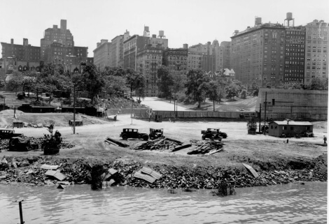
Meanwhile, in 1985 Donald Trump purchased the abandoned Penn Central railyard between 59th and 72nd Streets with the intention of building the city’s tallest skyscraper. Many objections were raised to this plan, but finally in 1991, Trump gained the City’s approval for his project by agreeing to build several smaller buildings and a 21.5 acre public park. Thus, Trump Place and Riverside Park South were born. Designed by Thomas Balsley & Associates, the first of six phases of the new park broke ground in November 1998. In April 2001, Phase I of Riverside Park South, a 7-acre section from 72nd to 68th Street was officially opened to the public. This section of the new park includes a soccer field, basketball courts, handball courts and a recreational pier. 
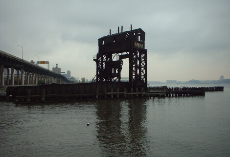
Pier I, at 70th Street in the Park, was originally part of the railyard and was reconstructed to its original length of 795 feet, but where it was once wide enough to fit four parallel railroad tracks, it has been narrowed considerably and is now only about 55 feet at its widest part. Most piers are perpendicular to the shore, but Pier I was built at a 55E angle to the shore to facilitate the transfer of rail cars from their tracks to a waiting barge.

Gantry in Riverside Park South

Phase II of Riverside Park South stretches along the river from 70th Street down to 65th Street, south of the pier. The design of Phase II includes two plazas, at 66th Street and at 68th Street, and a natural riprap shoreline. The park hosted joyous Caribbean-themed celebration and family event as a grand opening for this new section in early June of 2003. Phase III is another waterfront section of the Park that starts at 65th Street and continues down to about 62nd Street. It was opened in August of 2006 to the sound of train whistles, in honor of the site’s former use as a railyard. Phase IV, the southernmost waterfront section of the Park, opened in 2007. One of the unique features of this section is a train locomotive — a literal reminder of the site’s history as a former train yard. No. 25, is a 60-year-old, 95-ton engine that most recently labored on the Brooklyn waterfront. Now in its retirement, it is the centerpiece of a plaza at 62nd Street, and a play destination for young and old alike.

People walk and relax in West Harlem Piers Park
West Harlem Piers Park

West Harlem Piers Park is another relatively new space along Riverside Park’s six mile stretch. In 1998, local organization WE ACT for Environmental Justice (WE ACT) partnered with New York City Community Board 9 to organize the Harlem-on-the-River Project. Community leaders and residents organized to develop a community-driven plan that would increase access to the Harlem waterfront and bring attention to one of Northern Manhattan’s neglected neighborhoods. More than 200 residents worked with elected officials and representatives from the New York City Department of Parks and Recreation to create a community vision plan for the waterfront. The plan was submitted to the New York City Economic Development Corporation (EDC) by WE ACT in 1999.

In late 2000, EDC scrapped requests for proposals for commercial development at the site and instead developed a master plan based on the Harlem-on-the-River community plan. Approval for the final West Harlem Waterfront Park plan came in 2003 and applications for construction were quickly completed. A groundbreaking took place in October 2005, and construction on the Park was completed in late 2008.

The park was officially opened as the West Harlem Piers Park on May 30, 2009, and today features beautiful gardens and open river views for people to enjoy all year.

Old fashioned cars parked at a jagged shoreline at 79th Street on the west side
West 79th Street in 1935

Riverside Park is a remarkably complex and unique public space. It is layered in every sense of the word: Topographically, there is a significant grade change from Riverside Drive to the Hudson River waterfront, allowing for multiple levels of varied parkland; and historically, the park design encompasses three significant design movements of the late nineteenth and early twentieth centuries. The fine bones of the park show the style of architect Frederick Law Olmsted and the pastoral park movement of the late 1880s. The ornate retaining wall to the north of 135th Street exhibits the distinctive grandeur of the Beaux Arts movement. The complexity of the layers, at once visible and hidden, make it a place for historical reflections and a place of constant discovery.

Now in its third century, the Park is clearly in need of major repairs as its infrastructure ages. As it continues to evolve, and improve, the Park remains a gem – and a window into history – for all who visit.